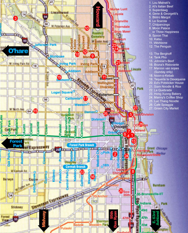
Chicago Chow Map
Chicago Chow Map
-
-
-
-
-
Chicago Chow Map
-
Post #1 - June 20th, 2004, 9:24 amChicago Chow Map
Created by CBDURR
Based on FAQ by Mike G

-
-
Post #2 - June 20th, 2004, 10:56 amI love this map, especially having the el overlaid, but I should mention that the el lines are transposed a little on this map from their actual locations.
For isntance, it shows the brown line as running along lawrence up near noon-o-kabob, spoon thai, etc, but it actually runs about a block and a half south of lawrence. The stations are also about two blocks further to the left than they should be.
An example:
On the map, Spoon Thai looks like about a 3 block walk from the Western brown line. It's really no more than a half a block.
The california blue line stop is also shown a ways away from its actual location (on California, half a block south of Milwaukee).
Basically, take the entire el map and shift it down and to the right a few pixels, and it's completely accurate.
-ed
-
-
Post #3 - June 22nd, 2004, 10:21 amIs this better? I had to approximate the right scale as well, so it still may need adjustment.

-
-
Post #4 - June 22nd, 2004, 2:22 pmBetter for the Brown line. The Blue to O'Hare runs along Milwaukee from the loop until Logan Square, when it moves over to the expressway.
-
-
Post #5 - July 8th, 2004, 2:32 pmI haven't tried yet but is there a good way to print these maps>
-
-
Post #6 - July 8th, 2004, 2:49 pmHi,
I will update the file image and leave the file for you to connect on your own and download, ok?
Regards,Cathy2
"You'll be remembered long after you're dead if you make good gravy, mashed potatoes and biscuits." -- Nathalie Dupree
Facebook, Twitter, Greater Midwest Foodways, Road Food 2012: Podcast
-
-
Post #7 - October 8th, 2004, 3:09 pmJust curious, is there nothing mapworthy South of Chinatown?
-
-
Post #8 - October 8th, 2004, 3:51 pm
Regrettably, this map was a snapshot in time based on a number of active posts on ChowHound.com.Brainerd Parker wrote:Just curious, is there nothing mapworthy South of Chinatown?
It would be nice if there were some Mapquest-like online service that would let you add a whole bunch o' destinations like this map.
With Microsoft Streets and Something or Other, you can build these kinds of maps, but it took a lot of effort on the parts of several folks to get the points and the CTA lines to line up.
-
-
Post #9 - December 30th, 2004, 4:18 amI'd be willing (this would be a labor of love/stuff to go on the resume, so no promises about how long it would take) to write some PHP code to allow interactive updating of this map (and other maps). The idea would be that the map image itself would be just a plain map without annotations. The URL for the map would actually point to a script that would read in the map, look up locations in a database, and "draw" them on the image before sending it out.
Users with the right privileges would be able to simply click anywhere on the map and then fill out a form that would let them put in the restaurant's name, address, phone number, style, and optionally a link to what they consider to be the first/best post describing the restaurant.
Any user could click on a numbered spot and see the above information for the restaurant. As I envision it, the restaurant names wouldn't be drawn on the map itself (to avoid crowding) but instead listed on the page below the map.
This scheme could easily be extended to multiple maps. Covering a larger geographic area with several maps would be one obvious use; another would be to have separate maps for groceries, butchers, and the like. Any decent JPEG/PNG map image could be used.
Mike G (or whoever handles the technical aspects of LTHForum) will need to give me some technical info if he/us decide to go ahead.
-
-
Post #10 - December 31st, 2004, 3:36 pmHI,
I've read recently pda's are already yesterdays technology. I always thought it would be nice to know what chow-friendly places were at or along my destination in Chicago, which your proposed map or grid-system may allow. (Downloadable to a portable device would be a bonus)
Presently, I use my mental rolodex, then hunt down the information to support my memory. Or I am already on the road, then do an On-Star consultation with someone from the board. I know I miss opportunities simply because they didn't come to my mind. The information is at LTHforum, though it is not presented intuitively relative to geography.
What you propose, if I understood it correctly, will go toward where to eat when I reach destination X. Not knowing what is involved software-wise, just thinking out loud, you could potentially have a mosaic map of Chicago with major streets outlined. If your destination is in the Albany Park neighborhood, then by selecting that piece of the mosaic links you to a blow up map of the immediate area with restaurants, specialty food shops, ect. noted by number/label/hyperlink to the location details and description as proposed. Or maybe there could be a mapquest tie-in, which I have seen on other sites, to get a street map and road instructions.
Sounds interesting ... just find the time will be the challenge from your side. Installing the information will be a challenge all around.
Thanks for thinking of LTHforum.
Regards,Cathy2
"You'll be remembered long after you're dead if you make good gravy, mashed potatoes and biscuits." -- Nathalie Dupree
Facebook, Twitter, Greater Midwest Foodways, Road Food 2012: Podcast
-
-
Post #11 - January 1st, 2005, 11:12 amWhen this puppy appeared first on Chowhound, I looked into some of what it would take to make it interactive, or database-updatable.
Regrettably, the tech behind address-to-lattitude/longitude is not open source, and would require some expensive licensing. A copy of Microsoft's Streets and (something) software gives you the data, and even an API, but you can't easily get that data onto an interactive server. You could use it for periodic updates, though.
It's going to be work, though. I've tried to cobble up a nice map on Microsoft's product, and it is hard to do things like emphasize the rail lines, show enough major street names, and still have waypoints (the restaurants) show up.
Drop me a note if you have some tech aspects that you get stuck on, I may be able to lend a hand.
-
-
Post #12 - January 2nd, 2005, 10:56 pmMy thinking was that the only positional information stored would be the pixel coordinates on the map image. That wouldn't help for Cathy's application, but it would avoid the need to use proprietary technologies.
-
-
Post #13 - June 6th, 2006, 8:50 pmObviously, eatchicago has demonstrated the powers of restaurant mapping with his Great Neighborhood Restaurant Award Map Seems like technology is converging on some of the ideas expressed in the early days of this thread.
is there any smart way to harness this kind of thing more widely in LTHForum? It seems like it could spiral out of control, but then, it always seems like help locating the good restaurants is welcome.
The ideal would be some kind of mechanism for tagging entries or threads, but it seems like it would be pretty cumbersome for most posters.
(Did you know that the Reader Restaurant Review pages are geotagged?)
JoelF wrote:Regrettably, the tech behind address-to-lattitude/longitude is not open source, and would require some expensive licensing.
There are some free address geocoders out there, most notably http://geocoder.us/
-
-
Post #14 - June 6th, 2006, 9:50 pmGPS coordinates can be dropped into Google Earth.
I have a GPX file of the restaurants listed in The Streets & San Man's Guide to Chicago Eats.
-
-
Post #15 - July 18th, 2006, 12:43 amI made a public map from the LTHForum list from January 2006. Check it out here: http://www.communitywalk.com/map/15346
There were some bugs in the bulk edit data, but it is an interesting proof of concept.Last edited by devehf on August 3rd, 2006, 8:02 am, edited 1 time in total.
-
-
Post #16 - July 18th, 2006, 7:23 amgermuska wrote:JoelF wrote:Regrettably, the tech behind address-to-lattitude/longitude is not open source, and would require some expensive licensing.
There are some free address geocoders out there, most notably http://geocoder.us/
Since I posted this, I've learned that both Yahoo and Google provide "free" geocoding, in the sense that if your application isn't too large, you don't have to pay them for it. Obviously not "free beer" since they could turn it off on you, but as far as I can tell, there aren't even commercial constraints if you don't wallop them with traffic. And they encourage you to cache the results, which is not what most of the old-school commercial geodata providers would say about it.devehf wrote:I made a public map from the LTHForum list from January 2006. Check it out here: http://www.communitywalk.com/map/13737
Interesting. I hadn't seen that site, but I was looking for something like that because I wanted to map the places in the Hamburger America documentary or maybe Edge's Fried Chicken book. Community Walk still looks a little rough around the edges, but it will be fun to explore.
-
-
Post #17 - July 18th, 2006, 7:34 amThanks, Devehf, though I have to ask what possesses someone in Idaho to create a map of food in Chicago?Watch Sky Full of Bacon, the Chicago food HD podcast!
New episode: Soil, Corn, Cows and Cheese
Watch the Reader's James Beard Award-winning Key Ingredient here.
-
-
Post #18 - August 3rd, 2006, 8:02 amHere's the new one. http://www.communitywalk.com/map/15346
You ask why would an Idahoan do such a thing?
We live in Idaho to escape the madness created by too many rats in the cage. Yet we miss the finer things in life that emerge from the clusters of cultures amassing in one place. So we come to Chicago for pilgrimages. We are here now and are headed out in search of good Indian.
-
-
Post #19 - August 3rd, 2006, 8:09 amWelcome to the big city, Devehf! Enjoy!Watch Sky Full of Bacon, the Chicago food HD podcast!
New episode: Soil, Corn, Cows and Cheese
Watch the Reader's James Beard Award-winning Key Ingredient here.
-
-
Post #20 - July 2nd, 2007, 2:56 amgleam wrote:I love this map, especially having the el overlaid, but I should mention that the el lines are transposed a little on this map from their actual locations.
Also, the 3-year-old map at the top of this thread is rather dated. Several of the places listed have closed. Users should check before heading out.

